Authors: Manuel Mendoza-Hurtado, Juan A. Romero-del-Castillo, Nicolás García-Pedrajas and Domingo Ortiz-Boyer
Status: Manuscript submitted for publication and currently under review.
ML-proxkNN is a new multi-label classification method designed to identify urban and regional functions from aggregated mobile phone activity.
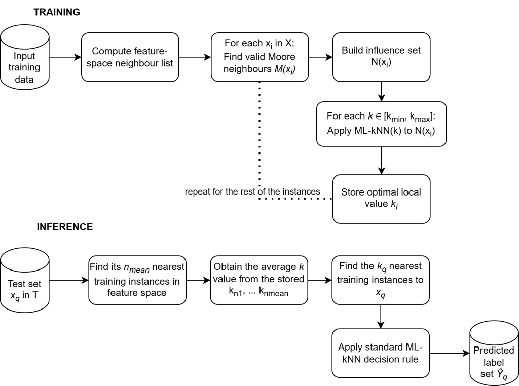
The method extends ML-localkNN, which assigns a different number of neighbours to each part of the feature space. ML-proxkNN additionally incorporates the spatial relationships between adjacent cells during the optimisation of these local neighbourhood sizes.
This allows the model to combine two types of information:
- similarity between temporal mobile activity patterns;
- geographic context provided by neighbouring grid cells.
Importantly, spatial proximity is used to improve the training process, but the final predictions are still based on similarity between mobile activity profiles. This avoids automatically assigning the same labels to all neighbouring cells.
Case studies
The method was evaluated using anonymised and aggregated Call Detail Record data from Telecom Italia for two contrasting regions:
- a 20 × 20 grid in Milan;
- a 15 × 15 urban grid and an additional 4 × 4 forest area in Trento.
The Milan dataset contains five labels describing residential and work-related functions and different levels of urban density. The Trento dataset also includes a forest label, reflecting its more heterogeneous Alpine environment.
Unlike single-label methods, the proposed approach allows each cell to receive several simultaneous labels. For example, an area may be classified as both residential and work-related, together with a specific density level.
Results
ML-proxkNN achieved an average precision of:
- 92.0% in Milan;
- 90.4% in Trento.
The method performed particularly well in comparison with conventional problem-transformation methods and remained competitive with other strong nearest-neighbour classifiers.
The contribution of spatial adjacency was more visible in Trento, where urban areas, villages and forested terrain create sharper geographical transitions.
We also used spatial block cross-validation, in which nearby cells were assigned to the same fold. This provides a more realistic evaluation of how the model performs when predicting complete areas that were not represented during training.
Main contribution
The main contribution of ML-proxkNN is the integration of spatial context into a locally adaptive multi-label nearest-neighbour model.
Rather than directly weighting predictions according to geographic distance, the method uses adjacent cells to determine the most appropriate value of (k) for each region of the training space.
This provides an interpretable and computationally efficient approach for applications such as:
- urban-function mapping;
- identification of residential, employment and mixed-use areas;
- analysis of density and land-use transitions;
- transport and infrastructure planning;
- comparison of urban, rural and forested environments.
The results should be interpreted as area-level functional proxies derived from aggregated telecommunications activity, not as precise information about the home or workplace of individual users.
Source code and data
The project repository contains the implementation, labelled grids, GeoJSON files and experimental results for Milan and Trento.
Overview of ML-proxkNN